Ie Beach (Photo by Shoji Kudaka)
On a day in mid-May I headed to north to visit Ie Island for the first time in more than a decade. A remote island that can easily be accessed from Okinawa’s main island by ferry, Ie is a popular destination for tourists and locals alike.
After seeing a news report on flowers blooming at the Lily Filed Park on Ie’s north shore, I decided to go back. A couple days later, I hit the road early in the morning to catch the first ferry from Motobu Port to Ie Island.
(Photo by Shoji Kudaka)
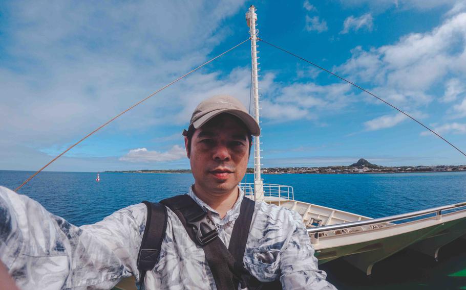
When I arrived at the port after a two-hour drive from the mid-section of the main island, it was already 8:50 a.m. The first ferry to Ie Island was departing in 10 minutes, so I quickly purchased a roundtrip ticket for 1,390 yen (approx. $9.72), rushed to the harbor and hopped on the boat.
As I caught my breath on the deck during the 30-minute trip, we passed Sesoko and Minna Islands as the view of Ie Island’s Mt. Gusuku became bigger and bigger.
As soon as the ferry docked at Ie Port, the first thing I did was to rent a moped at a shop by the port.
Although Ie is not big, I still needed something with an engine to move around on the island that has a circumference of 22.4 kilometers. Paying 3,500 yen for a 4-to-24-hour rental, I put on a helmet and hit the road on an old moped.
Since there was not much traffic, I felt relatively safe for a person who isn’t accustomed to riding a moped.
Mt. Gusuku
(Photo by Shoji Kudaka)
(Photo by Shoji Kudaka)

(Photo by Shoji Kudaka)
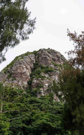
I was inclined to go straight to the lily field, but I decided to make a stop at Mt. Gusuku first.
Considered the symbol of the island with the moniker “Iejima-Tacchuu,” or a pointed figure of Iejima (jima means island), this 172-meter-high mountain used to be recognized as a landmark for ships traveling by. Since its rocky summit was constantly in my sight since I set foot on the island, it was just too hard to ignore.
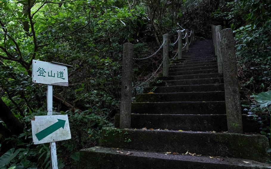
Although I had a map that the vehicle rental shop provided, I simply followed the direction of the mountain. Fifteen minutes later, I managed to reach a parking lot at the bottom of the mountain. Through a gate by the parking lot, I set foot on the trail to Mt. Gusuku.
The route to the mountain’s top was mostly covered by stone steps, so it looked like a smooth and easy climb. Well, looks can be deceiving. Five minutes later, I was out of breath.
Though the slope ran through the jungle, saving me from the harsh sunlight, beads of sweat were running down my forehead as I worked my way slowly up the steep slope.
Fortunately, my struggle didn’t last long. After about 10 minutes or so, I was out of the jungle and at the mountain’s rocky top. Since Ie Island is mostly flat, the mountain commands a breathtaking view.
Dazzled by the island’s beautiful landscape, I felt a little rejuvenated.
Wajee
(Photo by Shoji Kudaka)
Before I headed to the lily field, I had another spot to swing by.
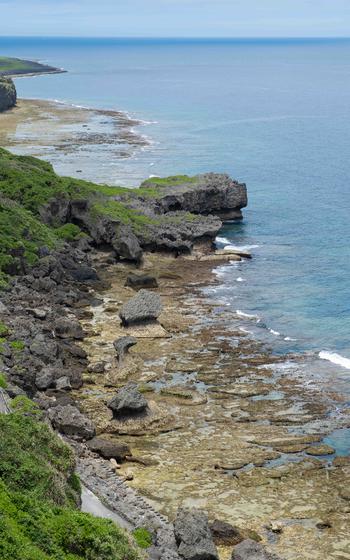
After riding the moped for 20 minutes, I arrived at Wajee, a lookout point on the northern coast that sits on cliffs as high as 60 meters. From the top of the cliffs, I could see the waves washing the coast as they drew various patterns and hues.
The name “Wajee” means “gushing.” It refers to the fact that this location is a source of water for locals. In the past, islanders had to come down the rocky cliffs to collect water. After the Battle of Okinawa in 1945, the U.S. military installed water pipes, which relieved the island of water shortage.
Lily Field Park

(Photo by Shoji Kudaka)
(Photo by Shoji Kudaka)
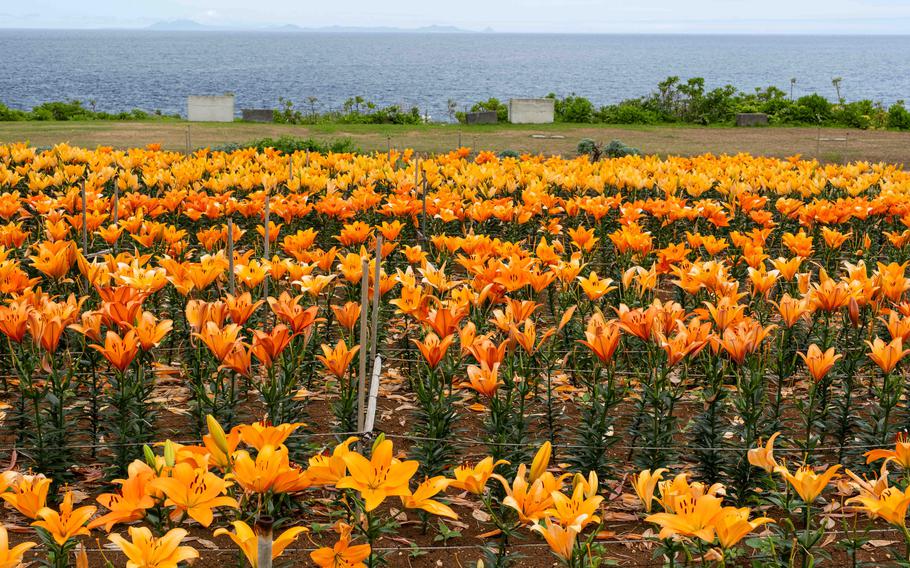
Riding the moped eastward for 10 minutes, I finally arrived at Lily Field Park. Although an annual lily festival had concluded 10 days before, the flowers were still in full bloom, decorating the field. According to Ie Village, the park is 8.60 hectares wide and home to one million trumpet lilies, plus another 100 kinds of lilies from around the world.
I had to walk quite a lot to see the flowers blooming on the big venue, but the spectacular view made it fun as well.
Hibiscus Park
(Photo by Shoji Kudaka)
On my way back to Ie Port along the east coast of the island, I had several stops to make. Hibiscus Park was one of them.
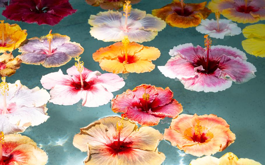
Home to 1,000 kinds of Hibiscus, this place has one of the biggest collections of the tropical flower in Japan.
At the entrance of the park, I was greeted by a small pool with various Hibiscus flowers floating. Being only familiar with red Hibiscus, I was surprised by the view.
Past the entrance, I entered a greenhouse where those flowers are farmed. There, the number of flowers seemed a little modest if compared with what I saw at the entrance, with the green color of the leaves predominant. However, once I began walking around the plants neatly lined up, Hibiscus were found here and there, making it feel like a small treasure hunt.
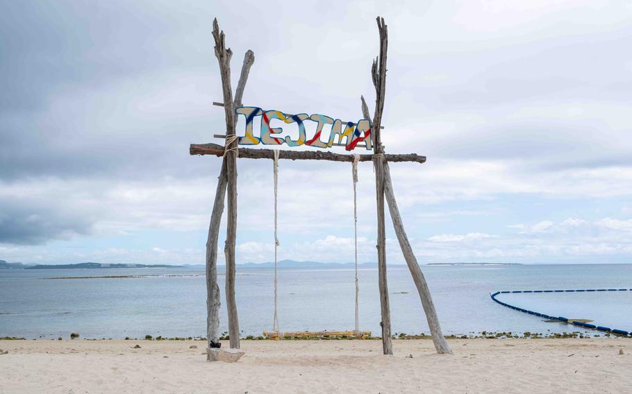
Ie Beach
Being on a tight schedule, I was not planning to get in the water on this day. But I still wanted to visit this beach that boasts a 1 kilometer of sandy shore.
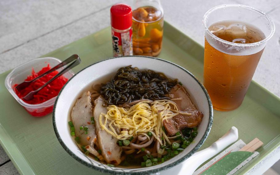
When I arrived, many teenagers were enjoying beach volleyball. There’s a wooden swing that sits on the shore, which is known as a popular Instagram spot. While I sat there and had fun taking selfies, it suddenly started to rain, forcing me to take shelter in a pavilion nearby. Luckily, I was able to buy Komugi soba (flour noodle for 800 yen) at a store by the pavilion and waited for the weather to clear up while slurping the chewy noodles.
(Photo by Shoji Kudaka)
There’s also a campground in the woods where you can set up a tent and spend the night for 300 yen. Campers can use a bathroom and a firepit in the area, plus a shower room by the beach.
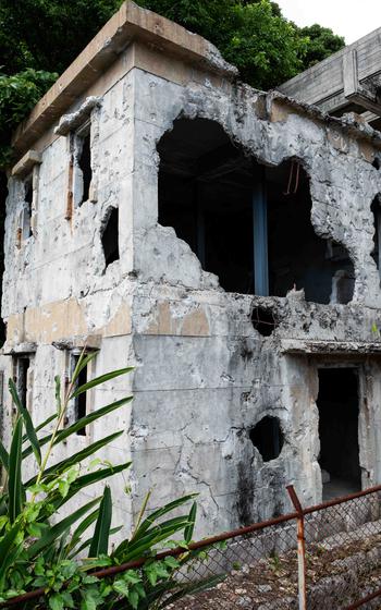
Koueki Shichiya-ato (Public Pawnshop Ruins)
(Photo by Shoji Kudaka)
During the Battle of Okinawa, Ie Island became a field of combat where a total of 3,500 Japanese military members and residents were killed. Koueki Shichiya-ato is a site that attests to such history.
I went there by taking a 5-minute moped ride from Ie Beach.
This building’s crumbling concrete and its walls peppered with bullets stood out in the quiet neighborhood.
According to Ie Village, it was originally built in 1929 to help villagers who were struggling with loan sharks after the Great Depression.
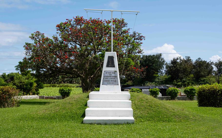
Ernie Pyle Monument
(Photo by Shoji Kudaka)
Near the end of this trip, I stopped by this monument dedicated to Ernie Pyle. Pyle is a Pulitzer Prize winner and war correspondent who was regularly featured in Stars and Stripes before he died on Ie Island while covering the battle of Okinawa in 1945.
Pyle, often referred to as “America’s most popular war correspondent” or “dogface’s best friend,” covered what enlisted men went through rather than the big picture of battles.
A month before my visit, an annual memorial service had been held at the monument with more than 120 attendees to pay tribute to the acclaimed journalist. On this day, I was the only there.
Still, the monument and the neatly trimmed grass around it presented a beautiful and peaceful scene which caught the attention of tourists passing by.
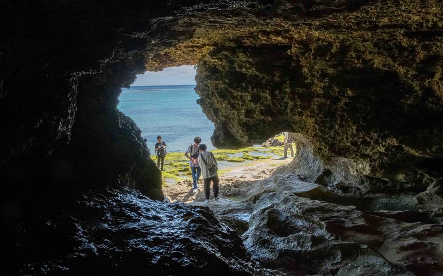
Niya-Thia Cave
(Photo by Shoji Kudaka)
This cave is a sacred site located on the south coast of the island and was the last stop I made before heading back to the port.
It is also known as “sennin gama (cave of 1,000)” because many villagers took shelter there during air raids.
When I visited the cave, I was first impressed with its size. I could not tell the exact dimension of the cave, but at first glance, it seemed bigger than a basketball court.
Through some gaps between rock walls, I could see the ocean shining in blue. Some visitors went out of the cave through one of the gaps, walking down the coast.
There is also a rock called “bijiru-ishi” on exhibit there. It is believed to let women have healthy babies if they can lift it. Being a male, I did not touch the stone, but it looked intriguing.
Back to the Mainland
The last ferry heading back to Okinawa’s mainland was departing Ie Port at 4 p.m. It was about 10 minutes before the departure time when I managed to hop on. I was surprised to know that I spent more than six hours on Ie, which is much longer than I had predicted. Although Ie is not a big island, it has a lot of appeals that are worth spending a day on.
Motobu Port
GPS Coordinates: N 26.640550, E 127.880018
*A round trip to Ie Island costs 1,390 yen.
*Parking costs 100 per hour with 700 yen at maximum for 24 hours.
Ie Island Port
GPS Coordinates: N 26.707555, E 127.801057
T.M. Planning (vehicle rental)
GPS Coordinates: N 26.708001, E 127.801576
Website: https://tmp.co.jp/carrental/
*Reservation required for vehicle rental.
Mt. Gusuku
GPS Coordinates: N 26.71911, E127.80641 (Parking lot)
Wajee Observatory
GPS Coordinates: N 26.732805, E 127.790169
Lily Filed Park
GPS Coordinates: N 26.737022, E 127.809997
Hibiscus Park
GPS Coordinates: N 26.724044, E 127.823958
Hours: 9 p.m. – 5 p.m.
Admission fee: 300 yen
Website: https://hibiscus.iejima.org/
Ie Beach
GPS Coordinates: N 26.709455, E 127.825466
Office opens from 9 a.m. – 5 p.m.
Admission fee: 100 yen for adults, 50 yen for children
Campsite usage fee: 300 yen for adults, 200 yen for children
Website: https://www.iejima.org.e.qz.hp.transer.com/document/2014121700044/
Koeki Shichiya-ato (Public Pawnshop Ruins)
GPS Coordinates: N 26.716643, E 127.805733
Ernie Pyle Monument
GPS Coordinates: N 26.710908, E 127.797980
Niya-Thiya Cave
GPS Coordinates: N 26.708800, E 127.771458