(Photo by Shoji Kudaka)
Nago Castle Park is a hot spot for cherry blossom-viewing in the winter as thousands of visitors come to enjoy the pink blush flowers. Nago-dake, a mountain just at the back of the park, does not receive the same glory.
After watching Japanese TV show Nihon Hyaku Teizan (100 low/small mountains in Japan) spotlight Nago-dake, my mind to visit was made up. So, I made a plan to head to this mountain to enjoy early fall in October.
Nago-dake sits at a height of 345 meters, about 20-meters shorter than Onna-dake in Onna Village. Though Nato-Dake may not be known for reaching high places, it makes up for it with other features.
From my experience at Nago Castle Park, I knew there were serval parking spots available. While some of them were located at the bottom of Nago-dake, others were close to the mid-section of the mountain. Trying to make the climbing route as short as possible, I headed to those on a higher ground, which left me three options: an observatory on the north side, Okinawa Prefecture Nago Youth Center, and another observatory on the south side.
Each parking spot offered different climbing routes with different challenges. The one that starts from the north observatory was mostly a paved road, while the other two cut through forested areas. Since I wanted to experience the deep forest landscape, I chose to start from the youth center.
After checking in and receiving a map of the mountain at the youth center, I headed to the start of the trail from a nearby camping ground shortly before 11 a.m. For the first 20 minutes or so, I enjoyed a moderate hike with slightly mountainous, bumpy points, moderate slopes and wooden steps. Unlike Mt. Katsuu or Mt. Ishikawa, where climbers are faced with some challenges, Nago-dake seemed to be very much part of the well-maintained public park. Walking on the road felt more like a picnic than mountain climbing.
Under the shade of the forest, I also enjoyed cool, comfortable temperatures. The buzzing of cicadas reverberated here and there. For a moment, I was under the impression that the summer was still lingering, but I soon discerned the buzzing with a metallic sound that is specific to ooshimazemi (meimuna oshimensis), a type of cicada telling of autumn’s arrival on the island. The landscape, though lush, had many brown leaves and no lingering summer flowers.
After a comfortable 40-minute walk, I reached a 3-way intersection. On Nago-dake, whichever route you choose, you will encounter several intersections. At each of them, signage will tell you where to go including the number to match to the point at your trail map. At this intersection, a “12” meant I could head up one direction to the peak, or a different way to connect to a route going north. Thanks to the map and the signs posted, picking the right one to the top seemed easy. However, 30 minutes later, I chose the wrong way for “11” on my map. Fortunately, I noticed my mistake and was able to correct it before going too far.
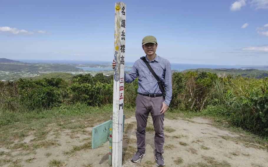
From trail markers “11” to “10,” the slope, as well as the wooden stairs, were steeper than at the start, making it seem very close to the top, which is number “9” on the map. When I reached “10,” I found myself on top of a ridge, where I could take a good look at the landscape surrounding the mountain for the first time and felt like I was at the summit. To my surprise, however, I had to go down steep stairs before going up a final slope to the top. Without any thick foliage to block the sunlight hitting the last stretch of the climbing route, I was covered with sweat. After 20 minutes of going down and up, a sign that read “名護岳山頂 標高 三四五M (The summit of Nago-dake, altitude of 345 m) finally came into my sight.
To be honest, I was not expecting a view much different from the one I saw at number “10.” But as soon as I reached the top, I was blown away. From the east to the northern forest to the west coast, it was a panoramic view I had never seen before in Okinawa. On the island where thick shrubs often ruin the view from mountains, this was a rarity. Even from Mt. Katsuu with a height of 452 meters, I didn’t have a view this good. The superb landscape was definitely worth all the sweat.
Reaching the summit was a highlight for sure, but it was not the last one. As I went back to the bottom, I chose a different route from the one I had gone up. Going down from “9” to “8” would take me to a paved road for an easy return. But this decision led me to a scary scene. The slope I chose to go down turned out to be quite steep. If had lost balance and stumbled, I could have fallen for 10 meters or even more. Luckily, I reached the paved road, without falling. From there, it was still a long walk back to the youth center, but the path was full of all kinds of butterflies and ferns, making it feel like a victory lap after conquering the mountain and surviving the steep downhill unscathed.
The views and easy challenges of Nago-dake made for a nice change of pace to kick off the fall season. No matter the time of year, Nago-dake is a fun place to enjoy the great outdoors at your own speed.