Hacksaw Ridge (Photo by Shoji Kudaka)
Since the 2016 release of Mel Gibson’s Academy Award nominated “Hacksaw Ridge,” there has been increased interest in the Okinawa site where the movie takes place.
Maeda Escarpment, a.k.a. “Hacksaw Ridge,” is now commonly recognized as part of Urasoe Castle Ruin. Urasoe City Office’s website says that since the movie was released, many people have come to see the actual site where Pfc. Desmond Doss rescued 75 or more people May 5, 1945.
Although the entire movie was shot in Australia, the film crew visited Maeda Escarpment according to Kiyomi Tamanaha of the Urasoe Association of history tour guides. Visiting the site surely helped in understanding the story of Pfc. Doss and the unique landscape around the cliff, which played a big role in the extraordinary event that took place 79 years ago.
Those interested in experiencing this piece of WWII history first hand themselves, have the opportunity to visit while stationed on the island.
Like those curious minds, I went to the escarpment to check out the real “Hacksaw Ridge.”
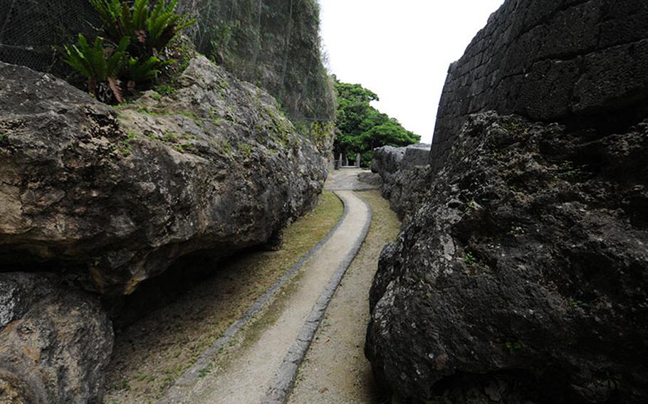
From a parking lot at the west end of the escarpment, most visitors, including myself, start their tour by going west on a path that goes around the hill.
I later learned that it was most likely from the opposite end of the escarpment that Pfc. Doss and his fellow soldiers of B Company, 1st Battalion, 307th Infantry, 77th Infantry Division approached the hill.
In search of what Pfc. Doss saw back then, I decided to reorganize the scenes I saw at the escarpment and lay them out in a way to follow his footsteps from east to west.
Needle Rock
Needle Rock is a 42.7 foot rock that stands on the east end of the hill top. This giant rock marked the U.S. military’s early approach to the escarpment.
“Okinawa: The Last Battle” a book by Roy E. Appleman, James M. Burns, Russell A. Gugeler and John Stevens, describes the 307th infantry’s initial approach to escarpment as follows: “When the 307th Infantry moved into the line on 29 April, it found itself on the flat top of an escarpment which at its eastern end at the Needle Rock was not more than two feet wide.”
According to the book, it took the U.S. Army nine attempts over five days to conquer the area.
In March of 2014, construction work was completed to prevent the huge rock from crumbling. Now visitors can take a close look at this monolith.
First flatland
Going westward from the Needle Rock, the hilltop widens gradually. Cutting through a collection of tombs on the northeast side of the escarpment leads to a flat space, which seems to serve as a staging area to the higher or more westward portion of the hilltop.
According to “Okinawa: The Last Battle,” Company A mounted four 50-foot ladders spliced together and cargo nets at the eastern end of the escarpment on May 1. But, every man who climbed to the top was killed. Meanwhile, Company B, which Pfc. Doss belonged to, used cargo nets farther to the west and succeeded in getting two platoons on the edge of the escarpment.
I could not find information on the exact spot where Company B hung the cargo nets, but looking up the hill from this flat space east of the Needle Rock, I could see Doss and his comrades setting up the nets to secure a foothold.
Going west on the flat space, visitors can see openings of bunkers and trenches that honeycombed the hill on the left.
According to “Okinawa: The Last Battle,” on May 2, 1945, smoke emerged from thirty hidden openings as a result of six phosphorous shells being shot into a cave. Seisho Oyafuso, a history tour guide who showed me around the place, explained that when south wind blows, air still runs through the caves and comes out of the openings on the slope facing north.
Going west on this flat space ends with a staircase that brings visitors to the higher ground of the hilltop. The location is about halfway between Needle Rock and the west end of the entire escarpment. Views from upper part of the escarpment may lure visitors to go up and eastward. But what they can see around the staircase is arguably the most important location for the story of Doss.
Desmond Doss Point
Although the so called Desmond Doss Point, the location where Pfc. Doss lowered the 75 injured soldiers, is a crucial part of the story, when it comes to its exact location, books and documents hardly present enough information. On the Google Map, “Desmond Doss Point” is supposed to be a spot near a viewpoint on the very top of the hill. The movie “Hacksaw Ridge,” depicts the rescue scene as taking place at a huge cliff.
But Chris Majewski, Director of the Battle of Okinawa Display on Camp Kinser, suggested differently. According to Majewski, to whom the information about the location was passed down in 1998 from Patrick Mooney, then a tour guide from Military History Tour who directly confirmed the location with Desmond Doss in 1995, explained that the point is near the staircase. If approached from the west, it is roughly 50 meters east from a pavilion on the top of the escarpment. The area near the staircase matches the description.
Circumstances also back up the information. Record suggests that the Japanese military used the west part of the escarpment as their stronghold. So, it would make more sense for Doss to bring injured soldiers away from enemies in the west.
*A sign is posted at the location to indicate the Desmond Doss Point.
Urasoe Youdore
Going up the stairs, taking a path to the right (west) takes visitors to another flatland much bigger than the first one. From the edge of this land visitors can take a look at the coastline and the island northward, a view that the Japanese military had as they scouted the moves of the U.S. military 79 years ago. The set of the major battle scenes of the movie “Hacksaw Ridge” seem to be modeled after this flat land.
In his book “Redemption at Hacksaw Ridge: The Gripping True Story that Inspired the Movie,” Booton Henderson describes the size of this space “about as wide as a football field,” which sounded about right to me.
This real hilltop of the Hacksaw Ridge may look smaller than in the film. But the compactness of the space attests to the close range combat that included everything from blasting pillboxes, bazookas and throwing grenades to mortars to hand-to-hand combat.
Located further to the west on the hilltop is a stone structure which used to be part of Urasoe castle. At the bottom of the stone wall there are openings which are thought to have been used by the Japanese military for scouting.
There are stairs lead to underneath the ruins where there is another historical site called, Urasoe Youdore, a 750 year old mausoleum of Ryukyu Kingdom.
Reverse slope
Beyond the hilltop on the south side of the escarpment, there are spots that tell the other side of “Hacksaw Ridge” story. Left in the so-called “reverse slope” are bunkers with unique names such as “Dog Biscuit Bunker”, “Canned Food Bunker” and “Fuel Bunker.” The names refer to how the Japanese military used them.
There were also natural caves where civilians fled. Entry to most bunkers are now blocked with wire mesh for safety reasons. But people can get close and take a look at the space where Japanese soldiers hid themselves during the daytime before heading out for sneak attack at night. Schematics are displayed at the entrance for some of them.
Understanding Hacksaw Ridge
Even with visiting the real “Hacksaw Ridge” and following the footsteps of Pfc. Doss and his fellow soldiers, it would be very difficult to understand exactly what happened back then.
Some of the landscape has changed significantly since the war. And 72 years is a very long time to think back to. In fact, many parts of the story still don’t seem real.
But, after taking a walk on the ridge and giving thought to the days Pfc. Doss and his fellow soldiers spent there, I find myself having a better understanding of just what those men experienced all those years ago.
Urasoe Castle Ruin (Urasoe Castle/Urasoe Youdore Museum)
Address: 2-53-1 Nakama, Urasoe city 901-2103
Admission: Entry to Urasoe Castle is free; Entry to museum is 100 yen (high school student and above) and 50 yen (middle school student and below)
Museum Hours: 9 a.m. – 5 p.m. (Closed on Mondays (except holidays) and Dec. 28 – Jan. 3)
Tel: 098 – 874- 9345 (Japanese)
Email: urasoerekisi@nirai.ne.jp
For tours at Hacksaw Ridge and other battle sites, contact MCCS Tours +:
DSN: 646-3502/098-971-3502/tours@okinawa.usmc-mccs.org. (www.mccsokinawa.com/tours/)