(Photo by Shoji Kudaka)
In search for some nature and the wonderful view I’d heard others mention, I took to Mt. Katsuu, or Katsuu-dake, for a nice day of hiking.
At 452 meters high (approx. 1,483 feet), Katsuu-dake is in Motobu peninsula and it is the third tallest mountain on Okinawa’s mainland.
Given its size, I definitely was not expecting an alpine-like adventure one enjoys climbing Mt. Fuji or Kilimanjaro, just a short hike to get some fresh air. My guidebook said this would only be 30 to 40 minutes to reach the top of Katsuu-dake.
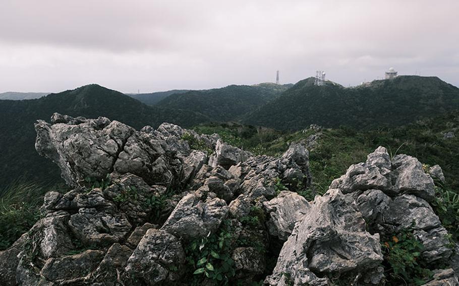
If you’ve visited Motobu Peninsula before, you may recognize Katsuu-dake as it has an exposed, lime-rock peak, unlike Yaedake and Awadake, the other mountains in the area.
Just like Daisekirinzan at the north end of the island, this mountain is composed of lime rocks from around 250 million years ago. While Daisekirinzan offers a safe and easy trekking experience, Katsuu puts you into the thick of the wilderness.
Access to the mountain was relatively easy. After about a one-and-a-half-hour drive north from the mid-section of the island, I found myself in a parking lot which connected to the starting point of the climb.
There were around 10 vehicles there, indicating some climbers already on the way. I started my trekking around noon.
The mountain trail started with a moderate slope but soon turned into a steep animal trail in the wilderness carpeted with numerous rocks. With thick and thin roots of trees running in between, it was difficult to even find a spot to take a step. Many of those rocks were slippery due to their mossy and wet surface.
The thick jungle made the trail look dark, but occasional pockets of sunshine filtered through the foliage. The moist stones glistened in the sun.
I saw many flora and fauna along the trail including ferns, asian taro and plenty of curious creatures here and there.
My easy hike became a jungle adventure with lots of weaving through a thick ocean of trees, but the cool sea breeze was very soothing. Had I waited to do this hike in the summer, there would’ve been more sweat and a higher risk of running into dangerous habu snakes.
After hiking about 20 minutes, I came to flat spot in the trail, which offered a preview of what was to come at the summit. A break in the thick branches and leaves showed the sky was still a bit cloudy, so I hoped the sunshine would return by the time I reached the top.
Soon, the trail led to another steep slope giving the wrong impression this ramp would lead me straight to the top. At various points the trail split in two ways, but thanks to red markers on stones and red ribbons tied on trees, I didn’t have to worry about getting lost.
As I was struggling with the slope, I ran into three climbers on their way back from the top.
“It’s very easy. It’s safe, I would say. We’ve done way worse and scarier hikes before. We were just actually talking about that,” Estonian Triinu Akimseu said with a smile. “In Slovakia, I’ve done a couple.”
“In Hawaii, Mt. Fuji,” her husband Lance Akimseu chimed in as he explained it took them only 24 minutes to go to the top of Katsuu-dake.
“It’s an easy pay-off,” said Will Michaels, who was hiking with the couple and was impressed with the view.
“You are almost there,” I heard of them call out to me as they made their way down the trail effortlessly.
About 10 minutes later, I was finally approaching the top. There were a few trees, but they didn’t have leaves to block my view. Seeing a wide view of the east coast of the island, I went on the final stretch. Then the top came into my sight with a pole reading: “Summit of Mt. Katsuu at 452m elevation.”
It was a panoramic view like I had never seen before. Both the east and west coastlines were clearly in sight. In the north, Yaedake could be seen beyond huge rocks. Although I could recognize locations such as Nago City and Kouri Island, the sight made me feel like I was in a different world.
Despite the chilly wind howling at me on the summit, the view was worth the trouble to get up there. Maybe it was the exercise, the adrenaline of reaching the top, or both, but what I saw up there really warmed my heart.
Mt. Katsuu (Katsuu dake)
GPS Coordinate (Parking lot): N 26.631142, E 127.939132
Parking: free *wearing trekking shoes strongly recommended.