Photos by Shoji Kudaka ()
Usually when the holidays come around, many of us who live on the island are inclined to head north where many beautiful beaches and mountains await. However, the southern part of Okinawa also offers plenty of lovely landscapes and an intriguing historical background worth getting to know.
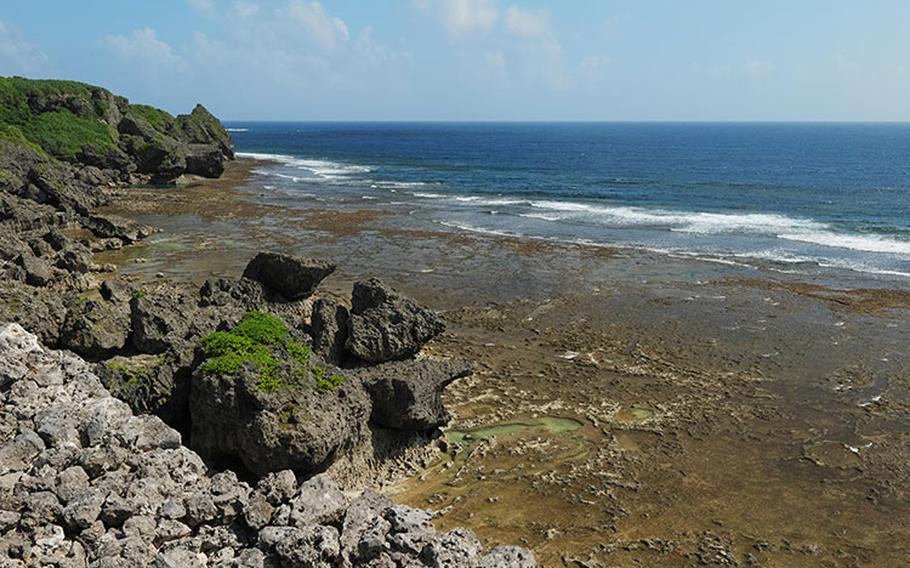
1. Giza Banta This cliff on the southern coast is about 40 meters above sea level and has a dark past. The site where many Japanese threw themselves to their untimely deaths during the 1945 Battle of Okinawa is also known as “suicide cliff.”
Compared to other historical points of interest nearby like the Peace Memorial Park and the Former Japanese Navy Underground Headquarters, Giza Banta is pretty low-profile. In fact, first-time visitors may find it hard to locate. Despite its tragic story, however, some might also call this a hidden gem because it offers a scenic ocean view and a chance to trek on a curious rocky terrain.
The cliff is about a five-minute drive northeast from the Peace Memorial Park and is accessible via a narrow street that branches off Route 331 near a golf course. There is a space at the end of the road where you can park your car. A slope runs by the cliff, taking visitors down to the coast. Although it is paved halfway through, the route becomes rocky and bumpy beyond that. With rocks being wet and slippery, it would be a good idea to wear shoes with good traction when you go there.
Along the coast spreads a lagoon, which is called “inoo” in Okinawa. Especially when tides are low, the rocky bottom of the sea will be exposed, creating innumerable shapes. This location is also known for waters that run down rock walls like waterfalls. When I visited the location recently, the stream of water was a little too modest to be called waterfalls but the vertical waterflow was unusual sight.
You can also take some concrete steps to the northeast of the cliff, through a tunnel to get to the coast. Getting to the steps requires navigating through shrubbery, but you’ll be rewarded with interesting terrain and more great views.
- GPS Coordinates: N 26.101033, E 127.734482
2. Odohama Kaigan (Odo Beach) About a five-minute drive west of the Peace Memorial Park, Odohama Kaigan is a hit among snorkelers and surfers. Similar to the coast off Giza Banta cliff, a vast lagoon spreads from the coastline.
Although you won’t find a 40-meter-high cliff there, a curious-looking statute welcomes visitors instead. Manjiro Nakahama a.k.a. “John Manjiro” is the person the statue is modeled after. Manjiro is known as the first Japanese person to set foot in the U.S.
According to the statue’s inscription, Manjiro was rescued by an American Whaling ship when he went adrift while fishing in 1841. The whaling ship took him to the U.S. where he became the first-ever student from Japan. After working as a crew of a whaling ship, and also mining gold in Sacramento, Manjiro purchased a whaling ship in Hawaii and head out to Japan. On his way back home, his ship made a stop on Okinawa’s Odo Beach in 1851 to avoid a storm.
Before being taken to Satsuma Domain for interrogation and departing for Tosa, his hometown in the southern coast of the mainland, Manjiro spent some time on the island interacting with locals. He would later serve as an assistant and a translator for the Tokugawa Shogunate (1603 – 1867), a surveyor and a whaler during the Meiji era (1868 – 1912).
Manjiro’s ship was named “Adventurer,” symbolic of his eventful life. At Odahama Kaigan, you’re looking out at the same view and walking in the footsteps the Japanese adventurer saw and walked 170 years ago.
- GPS Coordinates: N 26.089946, E 127.710291 (Manjiro’s statue)
3. Gushikawa Castle Ruins These castle ruins overlooking the southern coast of Okinawa boast a superb panoramic view. Though much of the original structure is gone and only some walls remain, curious stacked rocks provide a unique view similar to those at Nakagusuku Castle Ruins. There are also holes called “Hii Fuchimii,” which connect to the sea. According to an on-site commentary, these holes were for lifting and lowering supplies and equipment and for easy evacuation in the event of an emergency.
According to Itoman City, the castle is presumed to have been utilized between the 13th and 15th centuries. Although it is referred to as a spot for fishing and surfing, access to the beach was restricted when I visited.
- GPS Coordinates: N 26.080462, E 127.664563
4. Buckner Memorial This monument is dedicated to U.S. Army Lt. Gen. Simon B. Buckner Jr. who was the commanding general of the U.S. 10th Army.
According to Itoman City, Buckner was killed where the memorial now stands on June 18, 1945, just days before the end of the Battle of Okinawa. According to the US Department of Defense, Buckner was the highest-ranking military officer killed during the entire war.
There are memorials dedicated to Brig. Gen. Claudius M. Easley, assistant commander of the 96th Division, and Col. Edwin T. May of the 383d Regiment of the Ninety-sixth Army Division as well.
- GPS Coordinates: N 26.114648, E 127.680378
5. Hawaiian Cafe Dining KOA Since Itoman City offers many points of interest, this is a good spot to replenish your energy. Hawaiian Café Dining KOA on the beach is a perfect place for that. Its hearty loco moco (1,590 yen or approx. $11.50) can boost your energy with its tasty sauce, creamy cheese, and thick hamburger. If you got a sweet tooth, their pancakes (starting at 1,290 yen) are worth ordering. This cozy café with a nice ocean view and a laidback vibe can take you on a temporary trip to Hawaii.
- GPS Coordinates: N 26.117810, E 127.662568 - Hours: Mon-Wed-10 a.m. – 6 p.m., Fri-Sun, holidays, 10 a.m. - 8 p.m. (reservation required for dinner, after 5 p.m.), closed on Thurs. Website