(Shoji Kudaka)
Just east of Katsuren Peninsula, travelers will find an island known as “Kami no Shima,” translated to “God’s Island.” Hamahiga, the island’s proper name, is a small island with a lot to offer. Its landmarks and many shrines associated with the area’s ancestral mythology is why Hamahiga is known by its moniker.
Amamichu and Shirumichu are two of Hamahiga’s most sacred sites, named after a female and a male god, respectively.
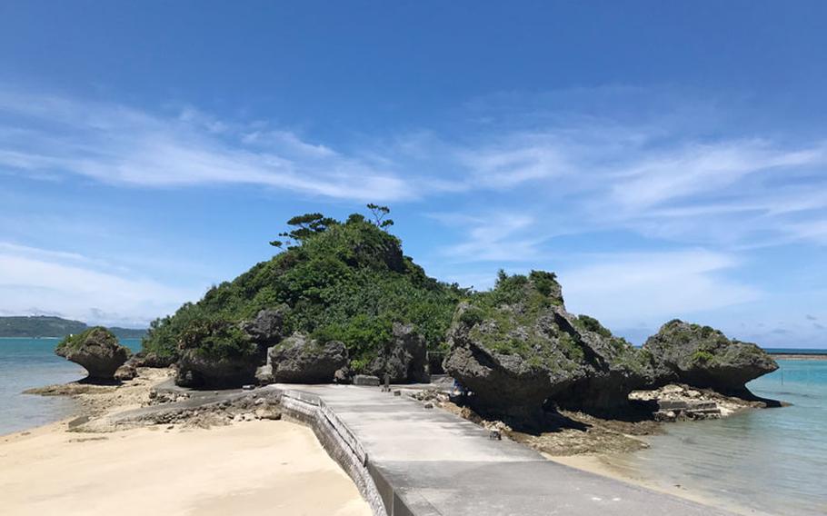
Amamichu is a tomb considered a power spot for those praying for fertility. Find this spot in a small islet on the island’s northeast coast. To get there requires a short drive from Hamahiga Ohashi bridge and a short walk on a concrete road. Look for a small sign at the end of the bridge that will point you in the right direction.
The road circles around the islet with huge mushroom-like rocks on the side. These rocks are commonly seen in Okinawa and thought to get their interesting shape from the rising tides and sea waves crashing onto them. The tomb itself is built into the rocks, and though its name may give the impression this is a shrine for the female god, it actually enshrines both Amamichu and Shirumichu. According to Uruma City Office’s website, “Noro” priestesses and locals visit this shrine during the Lunar New Year seeking blessings of productiveness, healt, and fertility.
Close by on the side of a hill near the island’s south end, “Shirumichu” offers a different perspective.
Enter through a Torii gate and climb up 108 steps to get to a cave opening. According to Urumajikan, a website owned by Uruma City, this is a place where the two gods are believed to have lived and given birth to their children. It is also host to Lunar New Year ceremonies involving dances and music. Entry to the cave is prohibited, but it is still a place of worship for those seeking help with starting a family.
Near Shirumichu, Sea Side Garden Hamahiga, a lodging facility, has an observatory on a rocky hill on its property that offers a vantage point of the island and the other surrounding islands. Also, on the premises is “Miruku Mon,” with its two giant rocks appearing to lean on one another, similar to “Sefa Utaki,” a UNESCO World Heritage site in Okinawa. Even if you’re not a guest at this lodge, you can enjoy the grounds for a small 300-yen (about $2.75) admission.
According to Uruma City, Hamahiga island covers about 605 acres of land in a 4.1-mile circumference. It’s a small island with many tourists eager to check out the sites. If you plan to visit this area, be aware that the streets are narrow and be respectful of the residential areas and especially the sacred sites you are sure to travel through. Drive carefully and enjoy all that Hamahiga has to offer.
Amamichu GPS Coordinates: N 26.324069, E 127.966271
Shirumichu GPS Coordinates: N 26.312240, E 127.959262
Hamahiga Sea Side Garden GPS Coordinates: N 26.313432, E 127.959391 *Free parking space is available nearby these sites
Muruku Hama Beach GPS Coordinates: N 26.318659, E 127.965272 *Parking fee costs 500 yen
Hamahiga Beach GPS Coordinates: N 26.325472, E 127.951609
Kaneku Beach GPS Coordinates: N 26.312690, E 127.960583