(Shoji Kudaka)
Last year in early May I set out for the north to hit the beach. Though the temperatures were still a bit cold ifor a swim, I couldn’t wait to take a dip in the ocean water any longer.
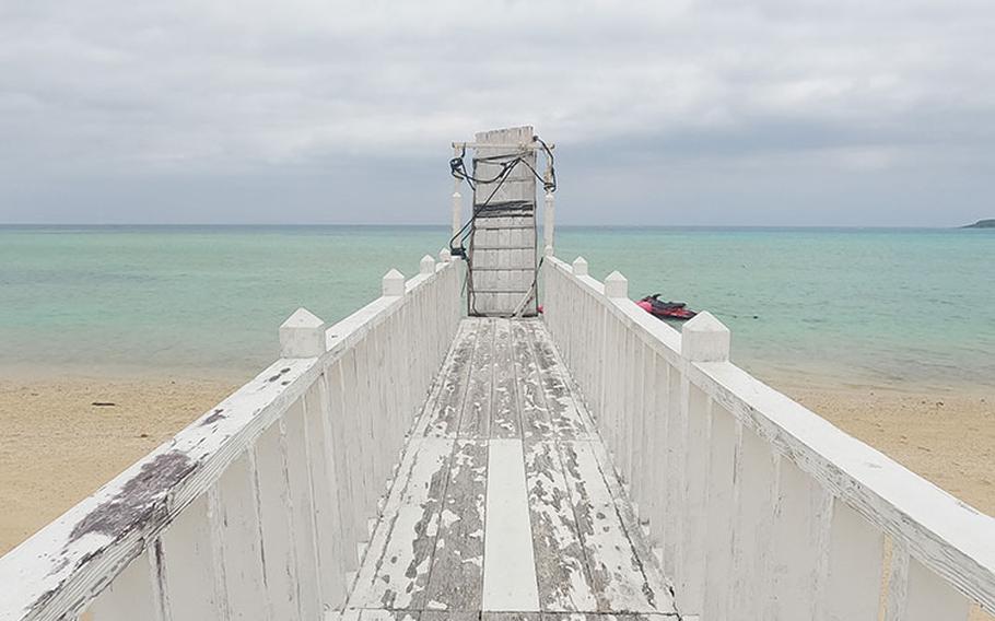
My destination on that day was Uppama Beach on the northern coast of Motobu peninsula. In Okinawan dialect, Uppama means “big sandy shore.”
Since my visit coincided with Golden Week, there were many tourists on the island. I wanted to avoid the crowds, and Uppama Beach was the perfect place with enough room to accommodate many visitors without feeling crowded.
Although Uppama Beach itself is a public beach and can be used for free, I decided to use Hotel Bel Paraiso’s paid services for convenience. I paid 500 yen for parking, 300 yen for showers and 500 yen for a beach parasol.
I expected many tourists on the beach when I left the shower room at the hotel but found there were only a few. I was the only one daring enough to jump into the water at first, too.
I had heard that this long stretch of white sand turned black when pumice stone swarmed Okinawa in 2021. Some black pebbles remained on the shore, but the beach looked beautiful as advertised, and the waters were clean.
Seated by the water’s edge, I put on fins, mask and snorkel. As expected, the water felt cold. I spent the first five minutes or so just bathing, soaking my body in the water to get accustomed to the temperature.
Once I started swimming, the peaceful waters felt comfortable and not too cold. The ocean floor was mostly sandy, so I didn’t have to worry about scratching myself against rocks and coral.
At first, I didn’t see any fish, which disappointed me a little. However, after a few minutes my eyes got used to the underwater and I saw small fish swimming here and there. At one point, I found a concrete structure that appeared to be used to moor a boat. As I approached it, I could see many fish in the area. They didn’t seem to be bothered by the unexpected swimmer who hit the beach a little too early. I guess they were just taking it easy in the peaceful waters just like I was.
I was about 20 meters offshore and thought if I swam out a little further, I could have seen more fish. But my legs started cramping so I stayed closer to the shore.
I spent about 40 minutes in the water then took a rest under the parasol and enjoyed the views of the beach and Kouri Island off in the distance.
If you are into adventure, Uppama Beach may not be at the top of your list, but if you are looking for a beach where you can relax and enjoy a swim with some fish, this is a perfect destination.
Uppama Beach GPS: N 26.691585, E 127.991939
Hotel Bel Paraiso GPS: N 26.69125, E 127.99261 *parking fee costs 500 yen at Hotel Bel Paraiso *use of shower costs 300 yen
Uehara Soba After crossing Warumi Bridge, I found a sign with the letters “Uehara そば(soba)” and an arrow. Following the arrow took me to this soba joint on the southern coast of Yagaji Island. It was housed on the second floor of what appeared to be an apartment building. From how it looked on the outside, I was expecting a modest (and quaint) looking eatery, but this place turned out to have a café-style interior.
Uehara Soba was packed with many customers, most of whom appeared to be tourists from mainland Japan. Fortunately, I could secure a seat by the window facing Haneji-naikai (inland sea).
From their extensive menu, I had a hard time picking my lunch. I settled on Uehara Soba (1,200 yen), which came with pork ribs, pork belly, and ashitebichi (pig’s feet) as sides (or toppings). It seemed to be a good deal because the three toppings are a golden trio for a soba enthusiasts like me.
Five minutes later, the food was brought to my table with more quantity than I had expected, which made me happy. With fatigue kicking in after the first swim of the year in the ocean, this was exactly what I needed to rejuvenate myself.
The soba was slightly brown, somewhat different from the pale color of Okinawa’s local soba. I learned later that Uehara uses wheatmeal and powdered bonito fish in their noodles.
The soba was cooked to a perfect, chewy texture. The pork-bone broth was rich and different from the usual bonito-based stock you’ll find in other soba noodle bowls. The broth’s rich taste hit the spot and the toppings all paired deliciously with my meal. I was glad I happened to stumble across Uehara Soba because I left with a satisfied tummy and recharged battery for the long drive home.
Hours: 11 a.m.–4 p.m. *Closed on Thu. GPS: N 26.658899, E 128.014538
Yagaji Tideland Before crossing Yagaji Ohashi, a bridge to Ojima Island and further east to Okinawa’s main island, I decided to swing by this dry beach west of Yagaji island. While Yagaji Beach on the east coast was crowded with campers and beachgoers, this tideland on the west was very quiet. There were only a few people there, most digging the sandy beach, possibly looking for clams.
It was around 2 p.m. and the tide was low, so I strolled about 100 meters on the tideland away from the shore before reaching the water. There were numerous holes in the sandy ground but no sign of crabs or any other sea creatures.
This tideland is known as a haven for wild birds, such as oxeye, white-eye, and eastern reef heron. It is also a destination of migration for birds like Terek and black-headed gulls in autumn through winter.
I didn’t bring binoculars with me so I couldn’t tell which birds were with me on the tideland. The birds confirmed their presence with chirping and swooping, adding to the serene atmosphere.
GPS: N 26.646057, E 128.032770 *Free parking space available
Warumi Bridge When I got back on shore, I had worked up an appetite, so I took a drive in search of some sustenance.
On my drive, I hit Route 505, which cuts through Motobu Island. Two years ago, I cycled this area on a road bike and the memories of the uphill slopes along the road came flooding back. At the time, I was too exhausted from cycling to enjoy the views, but this time, behind the wheel, I could appreciate the lush greenery and peaceful mood of the area.
Eventually, I turned on Route 248 and headed east. A few minutes later, I approached Warumi Ohashi (bridge). The 315-meter-long bridge connects Nakijin Village’s Amesoko District and Yagaji Island and is the fifth longest among all concrete arch bridges in Japan. At 37 meters above sea level, its height offers great views of Kouri Island, Kouri Bridge and the strait between Motobu Peninsula and Yagaji Island.
To the south, Haneji-naikai, an inland sea often called “Okinawa no Setonaikai,” because of its similarity to a famous inland sea in the western part of Japan’s main island, can also be seen.
After leaving my car in a parking area nearby, I took a walk on the bridge which opened in 2010. Though relatively new, the bridge now seems to fit into its surroundings. The view of the peaceful waters was also alluring and soothing, letting me forget about the time (and hunger) for a short while.
GPS: N 26.667269, E 127.994809 *Parking space available at (N 26.668458, E 127.993135)